Regional Initiative: Senegal to Gabon

Turning Earth Observation and Satellite Data into Africa's First Operational Regional Coastal Flood Early Warning Platform

SAFECOAST transforms satellite and ocean model data into actionable flood forecasts, giving West and Central African coastal communities — from Senegal to Gabon — the tools to anticipate, and not just endure, coastal hazards.

Data Gap Challenge

Bridging the Gap Between Scientific Research and Operational Protection

The West African coast, stretching from Senegal to Gabon, is among the regions most exposed to the impacts of climate change. Sea-level rise, intensifying storms, and increasingly frequent extreme weather events are accelerating coastal flooding and erosion across the region.

The economic and human consequences are severe. Rapid urbanisation, population growth in low-lying areas, and environmental degradation are continuously amplifying exposure and weakening coastal resilience.

~0M

people across Africa's North and West coastal zones are projected to be exposed to sea-level rise by 2030.
(Source: IPCC AR6 WGII, Ch. 9; Africa Center for Strategic Studies analysis)

$0B

in damages in 2017 alone for Benin, Côte d'Ivoire, Senegal, and Togo (5.3% of combined GDP).
(Source: World Bank, 2019)

0+

lives linked to coastal hazards in the region, a figure rising with urbanization.
(Source: World Bank, 2019)

"Nearly a third of West Africa's population and infrastructure is concentrated in the coastal zone. Yet across the region stretching from Senegal to Gabon, there is still no operational, science-based early warning system capable of forecasting coastal flooding in real time. SAFECOAST was built to close that gap."
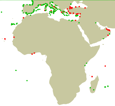
World Tide Gauge Stations

The In-Situ Data Void

In-situ tide gauges are virtually absent along the West African coast. SAFECOAST leverages continuous satellite Earth Observation to bridge this critical operational gap.

Contributing to Sustainable Development Goals
SDG 11 SDG 11
SDG 13 SDG 13
SDG 14 SDG 14

Our Solution & Technical Roadmap

A rigorous 3-phase scientific progression from satellite observations to ultra-high resolution modeling.

Phase A — ✅ Operational

Coastal Water Level Estimation

We compute Total Water Level (TWL) at specific coastal stations by combining Copernicus Marine Service ocean reanalysis data (~10 km resolution) with the empirical wave run-up formula of Stockdon et al. (2006). This provides a first operational estimate of coastal water levels along the Senegal-to-Gabon corridor, using freely available, continuously updated satellite and model data.

Phase B — ✅ Operational

Extreme Event Thresholds

Using a hindcast reconstruction back to 1993, we applied Generalized Pareto Distribution (GPD) extreme value analysis to define statistically robust alert thresholds for each station — moving beyond arbitrary warning levels to thresholds grounded in nearly three decades of ocean data and validated against documented extreme events.

Phase C — 🔧 In Development (Calibration)

High-Resolution Flood Modelling

Copernicus Marine's 10 km resolution cannot capture nearshore dynamics. We are developing a regional implementation of the SCHISM-WWM coupled hydrodynamic-wave model at 500 m–1 km resolution (10x improvement), covering the full Senegal-to-Gabon coastline in 2D forced by ERA5 data.

Partnership Need: We are actively seeking access to in-situ tide gauge data to strengthen model calibration and validation.

Geographic Scope & Regional Scaling

SAFECOAST's regional 2D model is designed to eventually cover the entire coastline from Senegal to Gabon. The number and location of high-resolution monitoring stations in each country will be defined based on local flood risk, priorities, and needs. Current pilot work is focused on Ghana, Benin, Nigeria, and Cameroon, chosen as representative high-priority sites for the calibration phase — with the ambition to extend to every coastal country in the region as funding and partnerships allow.

Why SAFECOAST Is Different

An innovative, cost-effective regional service built for long-term sustainability.

10x Finer Resolution

Moving from Copernicus 10 km to SCHISM-WWM 500m–1km resolution captures real nearshore dynamics driving coastal flooding — something no existing regional service provides for this coastline.

Regional Pooling

Rather than each country building separate tools, SAFECOAST shares infrastructure, model development, and technical maintenance — making operational-grade forecasting affordable for all municipalities.

First Regional Platform

From Senegal to Gabon, no operational, science-based regional early warning system for coastal flooding currently exists. SAFECOAST fills this critical gap.

Built for Continuity

SAFECOAST is designed as a long-term operational service with a sustainable capacity-building model — not a research project that ends when funding stops.

Explore our live demonstrator: A fully functional system running on real Copernicus Marine Service data, delivering GPD-based extreme event analysis and forecasts at our completed pilot stations (Phase A & B). Full regional coverage via SCHISM-WWM is being progressively integrated as Phase C advances.

West African Coastal Flooding Forecast System

Real-time operational forecasts & alert levels across pilot stations

No Flood
Warning
High Risk
Severe Flood

Region Status Map

Live Data

Location Details

Click map station for forecast & details

Daily Forecast Summary Today's Forecast

Site Name
Select Station
Max TWL
-- m
Status
--

7-Day Horizon

Date Max TWL Risk
Select a location...

Team & Scientific Guidance

Combines physical oceanography, remote sensing, and satellite hazard expertise.

FA

Fifi Adodo

Project Lead & Co-Founder

PhD in Remote Sensing / Cryosphere Science (Paul Sabatier University, in partnership with LEGOS), Master's in Physical Oceanography and Applications. Former research engineer at LEGOS (satellite altimetry, Antarctic ice sheet dynamics) and at Mercator Ocean International (ocean observation applications for the blue economy).

[Co-Founding Partner]

Co-Lead & Technical Specialist

Master 2 in Physical Oceanography, PhD in Earth & Environmental Sciences. Expertise in numerical coastal modeling, hydrodynamic wave coupling, and marine hazards analysis in West Africa.

Scientific Guidance: The team develops SAFECOAST with informal scientific guidance from researchers at IRD and LEGOS, and is actively building formal institutional and technical partnerships to scale the platform regionally.

Help Us Scale the First Regional Coastal Flood Early Warning System

SAFECOAST is seeking a minimum of €300,000 to move from pilot stations to full regional operational coverage over an estimated 3-year horizon.

Direct Use of Funds:

  • Regional scale-up of the SCHISM-WWM model across the Senegal-to-Gabon coastline.
  • Deployment of SCHISM-WWM at priority focus countries — Ghana, Benin, Nigeria, and Cameroon.
  • In-situ tide gauge sensors to calibrate and validate model forecasts against physical observations.
  • A multi-channel alert platform for last-mile delivery to local authorities and emergency managers.
  • Core team salaries to sustain year-round technical development and operations.

We welcome research grants, climate funds (GCF, Adaptation Fund), bilateral development partners, philanthropic foundations, and public agency contracts.

Discuss Partnership & Funding →

Building Our Partner Network

SAFECOAST currently develops with informal scientific support from researchers at IRD and LEGOS. We are actively seeking institutional, technical, and financial partners to help scale this platform regionally across West and Central Africa.

Reach Out to Collaborate

Contact Us

Discuss funding, research collaboration, or platform integration.

Get in Touch

Have questions about SAFECOAST, want to collaborate, or explore funding partnerships? Reach out directly!

Phone

+33 (0)7 58 01 11 83

Email

safecoastpro@gmail.com

Send Us a Message